EN
EN
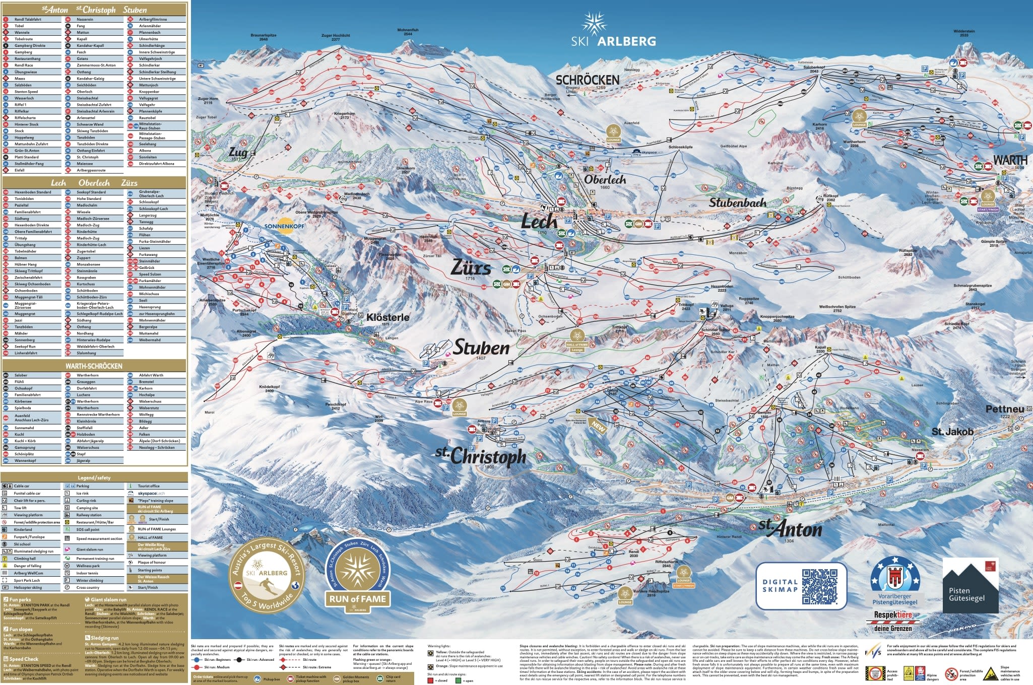
This sheet is St Anton's own skiing: the sectors rising north of the village, Rendl on its own across the valley, and the lift-linked villages of St Christoph and Stuben to the west. The Ski Arlberg pass reaches further than the sheet does — Lech, Zürs, Warth-Schröcken and Sonnenkopf sit on the wider Arlberg map and take the linked total past 300 km (186 mi) on one ticket.
So the sheet is a sector of a much larger pass, not the limit of where you can ski. If you're working out which ticket you actually need, here is how ski passes work.
St Anton ski resort guide · Ski Arlberg
Austria grades without green, so every easy run on this map is drawn blue — and St Anton's blues are steeper than blues almost anywhere else. Read the colours one step harder than you are used to and the sheet stops being misleading.
The second thing to notice is the dashed or outlined lines among the solid ones. Those are ski routes: marked and avalanche-controlled, but not groomed and not patrolled like a piste. There are 18 of them here against 62 pistes, which is a high proportion, and it is a large part of why the area skis bigger than its piste count suggests.
Geographically the map splits either side of the valley floor. Three linked sectors climb north of the village; Rendl sits alone to the south, with no ski link to the rest.
35 blue21 red6 black62 pistes, 18 ski routes, 38 lifts, 1,304 m to 2,811 m
The Galzigbahn lifts you from the village to 2,185 m, and from there most of the map is reachable without walking. Above it the Valluga cable cars climb to 2,811 m, the high point of the whole sheet, and the Schindler Spitze ground below carries the runs most people come for — Schindlergrat and Valfagehr among them.
If you only learn one part of the map, learn this one: it is where the day starts, where it funnels at lunchtime, and where it gets crowded after 10am.
The nearest skiing to the beds, reached from the village centre or from Nasserein at the eastern end. It is lower and more sheltered than Galzig, which makes it the sector that still works when the weather closes the top, and the gentler ground near the Gampen restaurant is the closest St Anton comes to a practice area.
Its own gondola from near the bus station, and no piste link back to the rest of the map — you ride down or ski the valley run and cross over. That separation is the point: Rendl holds its snow better than the sun-facing main sectors, stays quieter on a busy week, and has the snowpark.
Both are on this sheet and both are linked by lift, but they sit far enough west that people based in St Anton often never get there. Stuben is the one worth the trip on a powder day — north-facing, small, and the Albona ground above it is as serious as anything on the map.
Honestly: this is not a first-timer resort, and the map shows why — there is no green on it and the blues ski like reds. If you are learning, the Gampen and Nasserein ground is where to do it, and you should expect to progress faster than you planned because you have no choice. Worth reading where to go for a first ski holiday before you commit.
The best of the sheet. Loop the Galzig and Kapall sectors for long, consistent reds, then take the Rendl gondola for something quieter and better preserved in the afternoon. Valfagehr and the Schindlergrat descents are the two to aim at once your legs are in.
The reason the resort has the reputation. Valluga and the Schindler Spitze chutes above Galzig, the Albona ground at Stuben, the Kandahar black dropping back to the village, and the ski routes marked across the whole sheet. For the back of the Valluga you need a guide, and that is a rule rather than a suggestion. St Anton or Lech is the comparison worth reading if you want the same pass with less of the crowd.
On the same Ski Arlberg pass but on the other sheet, over the pass to the north. Lift-linked to St Anton the long way round, through Zürs and Stuben — doable in a day, but a day out rather than a quick hop.
A separate pass and a separate ski area one valley south, around 45 minutes by road. The usual swap for people who want St Anton's scale and nightlife with a higher, snow-surer map.
At the head of the same Paznaun valley as Ischgl, high and much quieter. Nothing like St Anton to ski, which is precisely why it comes up for families looking at the region.
Package holidays to St Anton am Arlberg with flights, transfers, accommodation and lift pass, all booked together.
See St Anton ski holidays