EN
EN
 Luxury resorts
 Top facilities
 Foodie paradise
 Hidden gem
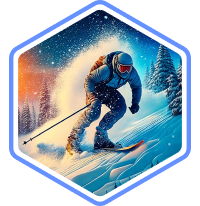 Off-piste skiingLuxury resortsTop facilitiesFoodie paradiseHidden gemOff-piste skiingLuxury resortsTop facilitiesFoodie paradiseHidden gemOff-piste skiingLuxury resortsTop facilitiesFoodie paradiseHidden gemOff-piste skiing
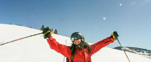
Andermatt is a historic village that's been defined by its mountain character for centuries. Sitting at the crossroads of four Alpine passes in central Switzerland, the setting is dramatic, with steep granite peaks, a compact village centre, traditional wooden chalets, and a sense of scale that still feels wild. It's a resort that attracts skiers who want a proper Alpine atmosphere without the crowds, and one that delivers modern lifts and infrastructure without compromising the village's charm.
The ski area is part of the Skiarena Andermatt-Sedrun, with 120km of pistes reaching up to 2,963m. Terrain ranges from gentle practice slopes to serious off-piste above the treeline, with the legendary Gemsstock mountain drawing powder enthusiasts from across Europe. Whether you're building confidence on blue runs or hunting fresh tracks, there's enough to hold your attention all week. The combination of high altitude and a north-facing aspect means snow conditions are typically reliable from late November through to late April.
Andermatt's appeal lies in its balance: serious skiing credentials, genuine mountain atmosphere, and enough off-slope options to keep everyone in the group happy. Beyond the slopes, Andermatt has grown into a year-round Alpine destination. The village centre is walkable and inviting, with a growing restaurant scene that mixes Swiss tradition with contemporary dining. The resort's newer development adds spa facilities, fine dining, and a polished edge without overwhelming the village's authenticity.
Check out Andermatt ski deals to start planning your trip.
Skiing and snowboarding in Andermatt is expansive and uncrowded. The Gemsstock side is a headline act. It's a north-facing mountain that holds snow well, rewarding confident skiers with some of Switzerland's best freeride terrain. Over on the Andermatt-Sedrun side, the slopes are wider and more forgiving, rolling across open bowls and through occasional larch forests with long, sweeping runs that suit intermediate cruisers and families.
The two areas have distinct personalities. Gemsstock is all about altitude and challenge, topping out at just under 3,000m, where the terrain is steep, exposed, and exhilarating. Andermatt-Sedrun, connected by the modern Gütsch-Express gondola, provides a gentler rhythm with well-groomed pistes, sunnier aspects, and a more relaxed pace. Together, they create a ski area that covers a broad range without ever feeling repetitive.
Beginners will feel most comfortable on The Andermatt-Sedrun side of the resort, where the runs are wide enough to avoid feeling hemmed in. Nursery slopes near Nätschen and the gentle blue runs around the mid-station areas provide a sheltered, manageable environment to find your feet. Modern lifts make getting around straightforward, with no awkward drag lifts to contend with on the main beginner routes.
As your confidence grows, there are longer blue runs that wind down towards Sedrun, giving new skiers a taste of proper Alpine descents without too much gradient. Slopes on this side tend to be on the quiet side, which makes the learning experience more enjoyable, with less dodging and more skiing.
WeSki insider tip: Stick to the Andermatt-Sedrun sector for your first few days. The runs around Oberalp are wide, well-groomed, and catch the afternoon sun. These are perfect for building confidence without the intensity of the Gemsstock side.
Intermediate skiers will find plenty to explore across both sides of the ski area. The Andermatt-Sedrun sector has long red runs with consistent pitch that are ideal for building speed and rhythm across open terrain. From Schneehüenerstock, the run down towards Sedrun is a highlight: a sweeping descent with good variety and views that stretch across the Graubünden mountains.
When you're feeling sharp and ready for more challenge, the gentler runs on the lower Gemsstock offer a step up. Reds here are steeper and more sustained, and you'll start to get a feel for the mountain's character. On good snow days, confident intermediates can venture onto some of the easier marked routes off the Gemsstock summit, easing into terrain that most resorts would reserve for advanced skiers.
WeSki insider tip: The Gütsch-Express gondola connecting the two sectors is the quickest way to shift between terrain styles. Use it to warm up on Sedrun's cruisers before heading to Gemsstock's steeper reds after lunch.
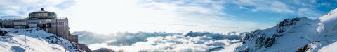
For advanced skiers, Gemsstock is the draw at Andermatt. A summit cable car drops you at 2,963m, and from there the options open up. You have steep marked blacks, sustained couloirs, and wide-open off-piste faces that funnel down to the valley through genuinely committing terrain. The north face holds powder for days after a storm, and the vertical drop delivers over 1,500m of sustained descent when conditions allow.
Marked black runs from the summit are steep and exposed, while the Gemsstock Sonnenpiste and runs towards Gurschen demand good technique and confidence. But for experts, the real prize is the off-piste. Routes like the Felsental and the Guspis Valley are accessible from the top station, though a guide is essential for anyone unfamiliar with the mountain. The terrain here is serious Alpine freeride, so avalanche awareness and proper equipment are non-negotiable.
WeSki insider tip: Book a mountain guide for at least one day on Gemsstock. Local guides know the snow conditions intimately and can take you into terrain that most visitors walk straight past.
Andermatt's terrain suits snowboarders well. Wide-open bowls on both sectors reward carving, and the Gemsstock's freeride terrain is a proper playground for experienced riders. The Andermatt-Sedrun side has natural features, with rollers, and side hits that keep things interesting on mellower days. Its modern lift system means minimal flat-tracking, though riders should be aware that the Oberalppass link can involve a short flat section.
Andermatt's off-piste reputation is well earned. Gemsstock is one of Switzerland's premier freeride mountains, with north-facing aspects that preserve powder and a variety of routes from steep couloirs to wide alpine bowls. The Felsental, Guspis, and the runs towards Hospental provide genuine backcountry descents accessible from the lift system. Always ski with a guide, carry avalanche safety equipment, and check conditions carefully, because this is proper high-mountain terrain.
Several ski schools operate in Andermatt, including the Swiss Ski School Andermatt and Snowsports Andermatt. Group and private lessons are available for all ages and abilities, with English-speaking instructors readily available. Lessons cover everything from first-timers to off-piste guiding and technique clinics.
Through WeSki, you can add ski or snowboard lessons to your package and have everything arranged before you arrive. Check out Andermatt ski deals to get started.
The ski area has a terrain park on the Andermatt-Sedrun side, typically set up with a mix of jumps, rails, and boxes suited to intermediate and progressing freestyle riders. It's not a headline park, but it's well maintained and a fun addition for riders looking to progress their park skills between freeride laps. Features here tend to be adjusted throughout the season based on snow conditions.

Andermatt works well for families, particularly those with children who already have experience on skis. Its compact village centre means everything is within walking distance, so parents don't need to worry about long transfers or complicated logistics. The Andermatt-Sedrun sector's gentle terrain make it a comfortable environment for younger skiers, and the gondola-connected layout means the family can split up and regroup easily.
Snow gardens and kids' clubs cater for the smallest members of the group, and the ski school pick-up and drop-off areas are easy to find. Older children and teenagers enjoy the variety at Andermatt as their ability grows. There's enough terrain to keep them challenged without having to travel far, and the terrain park provides a welcome distraction for freestyle-curious teens.
Overall, the atmosphere is welcoming and entertaining - great for kids without being overly sanitised. Non-skiing activities like tobogganing, ice skating, and swimming at The Chedi's facilities give everyone options on rest days. Dining in the village is family-friendly, with plenty of restaurants serving Swiss classics in relaxed settings.
Andermatt's dramatic valley setting and growing village infrastructure make it well suited to rest days, non-skiers, and anyone looking for a slower pace. From scenic mountain railways and winter walks to wellness facilities and cultural excursions, there's plenty to enjoy away from the pistes, and the compact village means nothing feels like a mission to reach.
The Urseren Valley provides a spectacular backdrop for winter activities beyond skiing and snowboarding. Whether you're looking for a gentle afternoon or something more adventurous, these options make full use of the high-altitude setting:
For days off the slopes, Andermatt has a growing range of options that combine wellness, culture, and Alpine scenery:
Andermatt's dining scene is one that truly stands out. The village has an exciting range of restaurants, from traditional Swiss mountain cooking to polished fine dining. Mountain restaurants add a scenic lunch dimension that makes midday breaks something to look forward to.
WeSki insider tip: Swiss cuisine rewards the adventurous. Try a proper cheese fondue at one of the village restaurants and order it with kirsch as the locals do. Raclette is another must, and the rösti here is a world away from anything you'll find at home.
Andermatt's après-ski scene has a relaxed vibe, where you can enjoy sociable drinks, good conversation, and an overall lively evening. After the lifts close, skiers tend to drift into the village's bars for a beer or glühwein before heading to dinner.
There's enough variety to keep things interesting across a week. Newer hotel bars and lounges add a polished dimension, while the traditional village pubs have a low-key warmth that makes you want to stay for another round. Weekends can pick up, particularly when the Zurich crowd arrives, but the overall vibe remains friendly and laid-back.
Après-ski spots to know:
Accommodation in Andermatt ranges from luxury five-star hotels to traditional guesthouses and self-catering apartments. Hotels like the Chedi Andermatt and Radisson Blu anchor the premium end, located in the newer Andermatt Swiss Alps development adjacent to the village centre. The original village has a charming collection of smaller hotels, B&Bs, and holiday apartments, many within a few minutes' walk of the Gütsch-Express gondola.
The resort is compact, and most accommodation is within 10-15 minutes' walk of the main lift stations. Staying in the village centre puts you closest to restaurants and bars, while the Andermatt Swiss Alps development feels more modern and spacious. A ski bus connects the main areas to the lifts throughout the day.
The Andermatt-Sedrun-Disentis ski pass covers all 22 lifts across the connected ski area, giving access to 120km of pistes. For those staying longer, the pass also grants access to the Disentis sector, extending the terrain further into Graubünden. Multi-day passes are the most common choice and provide the best flexibility across the full ski area.
Check for family and multi-day pass options when booking your Andermatt ski holiday package through WeSki to find the best fit for your trip.
Several rental shops operate in Andermatt village and at the lift stations, offering a full range of ski and snowboard equipment. You'll find options from budget packages to premium demo-level skis and boards. In-resort shops can also handle boot fitting and adjustments, which is worth doing on your first morning, and most shops offer overnight storage so you don't need to carry gear back to your accommodation each day. Booking equipment in advance is recommended during peak weeks.
Andermatt is a compact resort, and most of the village is walkable. The main lift stations, restaurants, and shops are all within a comfortable stroll of most accommodation. A ski bus runs regular circuits connecting the village, the Andermatt Swiss Alps development, and the main gondola stations throughout the ski day, which is useful if you're staying slightly further out.
In the evenings, the village centre is easy to navigate on foot, with distances that are short and the streets are well maintained. Taxis are available for late-night journeys or transfers to outlying accommodation, though you're unlikely to need them often given the village's size.
Andermatt is well connected by road and rail. Zurich Airport is the nearest major hub, around 110km to the north, and Milan Malpensa is another option for flying, around 180km away. The train journey from Zurich is one of the most scenic airport-to-resort transfers in the Alps, with direct connections via Göschenen and through the Schöllenen Gorge. Driving is straightforward via the A2 motorway and Gotthard tunnel.
WeSki provides car rentals from the airport as well as private transfers to Andermatt. Add them to your Andermatt ski holiday package for seamless door-to-door travel.
Andermatt suits beginners on the Andermatt-Sedrun side, where gentle blue runs and nursery slopes provide a comfortable learning environment. The terrain is wide and uncrowded, which helps with confidence building. The Gemsstock side is better left until you've progressed to intermediate level, since it's steep and more suited to experienced skiers.
Both are serious Swiss ski resorts, but they feel quite different. Andermatt is quieter, more compact, and has a traditional village atmosphere with excellent freeride terrain on Gemsstock. Verbier is larger, with a more extensive lift-linked ski area and a livelier après-ski scene. Andermatt tends to attract skiers looking for quality terrain without the crowds.
Andermatt has a strong reputation for snow reliability. The resort's position at a high-altitude crossroads catches weather systems from multiple directions, and the Gemsstock's north-facing aspect preserves snow well. The season typically runs from late November to late April, with the best conditions generally found at higher elevations.
Andermatt sits at the higher end of Swiss resort pricing, particularly with the newer luxury hotels. That said, traditional guesthouses and self-catering apartments provide more moderate options, and the village has a range of dining from casual to fine dining. Ski passes are comparable with other major Swiss resorts.
Gemsstock is Andermatt's star attraction for experienced skiers. The summit reaches 2,963m, and the terrain is steep, north-facing, and renowned for holding powder. Marked black runs are challenging and sustained, while the off-piste options - best explored with a guide - are among the finest in Switzerland. It's not beginner-friendly terrain.
Yes, and it's one of the best ways to arrive. Regular trains run from Zurich via Göschenen, with the journey taking under two hours. The route through the Schöllenen Gorge is spectacular, and Andermatt sits on the Glacier Express route, making train connections straightforward from across Switzerland.
 4.9/5
4.9/5I usually book flights, transfers, hotel, ski rental and lift passes myself but this year used WeSki for a trip to Morzine. It was so much easier. Everything worked perfectly - transfers arrived on time and there was plenty of feedback throughout the whole process giving you confidence the holiday would go smoothly.

A really useful service that is so much easier to use than other 'all-inclusive' sites. It nicely bridges the gap between a travel agent and booking the trip yourself online. I will use WeSki every time I go skiing from now on.
We booked a late minute skiing trip to Morzine through we ski. We looked at booking the trip ourselves but could get anywhere near the price quoted by we ski. The company was excellent and we had no problems at all from start to finish. I would definitely use them to book another weekend skiing trip.
Seamless experience from start to finish. I was spending ages trying to sort out a weekend break and managed to do it with we ski in minutes and for the same price as booking it all up yourself. Flight, transfer and accommodation was all as expected and faultless.
WeSki is a trading name operated by WeTrip Ltd. All the flights and flight-inclusive holidays on this website are financially protected by the ATOL scheme. When you pay you will be supplied with an ATOL Certificate. Please ask for it and check to ensure that everything you booked (flights, hotels and other services) is listed on it. Please see our booking conditions for further information or for more information about financial protection and the ATOL Certificate go to: www.caa.co.uk.
Package holidays that do not include travel by air are financially protected via ABTOT.
For the latest travel advice from the Foreign & Commonwealth Office visit www.gov.uk/foreign-travel-advice.