EN
EN
Nobody wants to arrive at a ski resort and find patchy cover and closed lifts. The resorts on this list have been picked for the factors that matter most when it comes to reliable snow: high altitude, strong snowmaking infrastructure, favourable aspect and - in several cases - glacier access that extends the season at both ends. Each entry explains what makes that resort dependable and who it suits. If you want to understand the science behind snow reliability before you compare, our guide to what makes a ski resort snow-sure covers altitude, aspect and snowmaking in detail. And for practical booking advice, our how to guarantee good snow on your ski holiday guide walks through timing, resort selection and what to check before you commit.

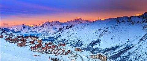
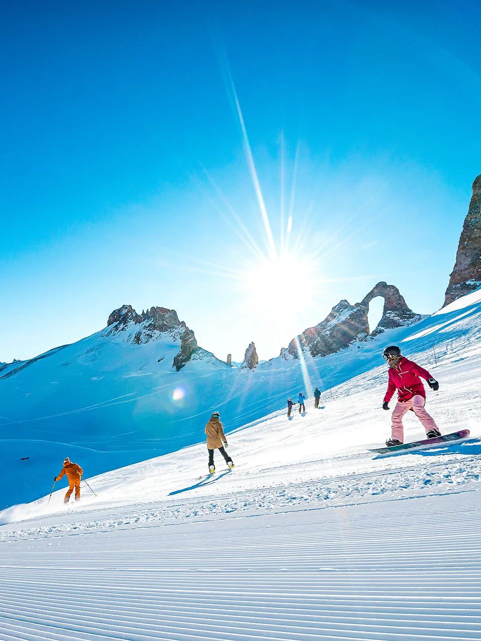
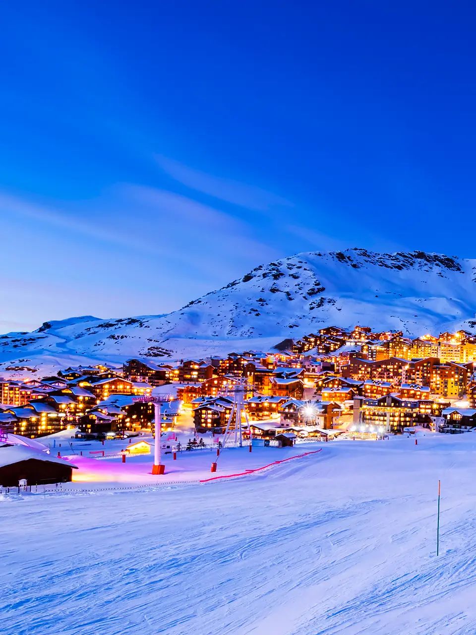
Europe's highest ski resort sits at 2,300m, with skiing reaching up to 3,230m on the Cime de Caron. That altitude means Val Thorens opens early - often in late November - and runs well into May most years. The snow record speaks for itself: the resort rarely drops below a two-metre base during the core season, and the upper slopes hold dry, cold snow when lower resorts are dealing with spring slush.
As part of the Three Valleys, you also have access to 600km of linked pistes if you want variety. But Val Thorens' own ski area is substantial enough for a full week without needing to venture far. The terrain suits intermediates particularly well, with long sweeping runs above the treeline, though there's challenging off-piste for advanced skiers too. The village is purpose-built and compact, which means everything is ski-in, ski-out.
| Why we recommend it |
|---|
| ✓ Highest resort in Europe at 2,300m - consistently deep snowpack from November to May. |
| ✓ Part of the Three Valleys with 600km of connected skiing for day-trip variety. |
| ✓ Compact ski-in, ski-out village with everything within walking distance. |
| Country | France |
|---|---|
| Ski area | Three Valleys - 600 km of pistes |
| Altitude | 2,300m - 3,230m |
| Snowmaking | 45% of pistes covered |
| Glacier access | No (altitude compensates) |
| Transfer time | Geneva (3h 30m); Lyon (3h 15m); Chambery (2h) |
WeSki insider tip: The Plein Sud sector above the resort catches morning sun and softens into lovely spring-snow skiing by mid-morning in March and April. It's the best area for late-season cruising.

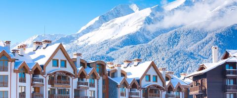
Obergurgl's reputation as one of Austria's most snow-sure resorts is well earned. The village sits at 1,930m - one of the highest resort villages in the Alps - and the ski area tops out at 3,080m. The combination of altitude and a position deep in the Otztal valley, shielded from warm Foehn winds, means snow conditions here tend to be excellent from mid-November through to late April.
The ski area is mid-sized at 112km of pistes, shared with neighbouring Hochgurgl. It's not the place for skiers who want to cover vast distances, but the quality of the terrain and the lack of crowds make up for it. Pistes are well groomed, lift queues are minimal, and the atmosphere is more traditional Austrian village than party resort. That mix of reliability and calm makes it a strong choice for families and anyone prioritising conditions over nightlife.
| Why we recommend it |
|---|
| ✓ Village at 1,930m with skiing to 3,080m - one of Austria's highest and most snow-reliable resorts. |
| ✓ Sheltered valley position protects against warm winds and preserves snow quality. |
| ✓ Uncrowded pistes with a traditional Austrian village atmosphere. |
| Country | Austria |
|---|---|
| Ski area | Obergurgl-Hochgurgl - 112 km of pistes |
| Altitude | 1,930m - 3,080m |
| Snowmaking | Over 90% of pistes covered |
| Glacier access | No (nearby Rettenbach glacier accessible by car) |
| Transfer time | Innsbruck (1h 30m); Munich (3h 30m) |
WeSki insider tip: The Hochgurgl side tends to be quieter, especially on weekends. The Top Express gondola takes you straight to 3,080m where conditions are coldest and the snow stays driest.

Cervinia sits at 2,050m and links across the Italian-Swiss border to Zermatt, giving access to one of the highest and most snow-reliable ski areas in the Alps. The local terrain reaches 3,480m on Plateau Rosa, where you're skiing on near-permanent snow cover. The altitude and predominantly north-to-east-facing slopes mean conditions here hold well throughout the season, with the upper runs maintaining excellent cover even in lean snow years.
The ski area is known for its long, wide intermediate runs - the descent from Plateau Rosa back to the village is one of the longest in Europe. It's a particularly good fit for confident intermediates who enjoy cruising. The Italian side tends to be sunnier and warmer in the village than Zermatt, with correspondingly better value on accommodation and dining. Snowmaking covers the lower sections comprehensively, ensuring the runs back to the village stay open even during warm spells.
| Why we recommend it |
|---|
| ✓ Village at 2,050m with skiing to 3,480m - one of the highest ski areas in Europe. |
| ✓ Cross-border link to Zermatt for an enormous combined ski area. |
| ✓ Long, wide intermediate runs with some of the most consistent snow in the Alps. |
| Country | Italy |
|---|---|
| Ski area | Cervinia-Valtournenche (+ Zermatt link) - 360 km of pistes |
| Altitude | 2,050m - 3,480m |
| Snowmaking | 60% of local pistes covered |
| Glacier access | Yes (Plateau Rosa) |
| Transfer time | Turin (2h); Milan Malpensa (2h 30m); Geneva (3h) |
WeSki insider tip: The Plan Maison area at mid-station is a brilliant warm-up zone on your first morning. The wide blues there get groomed overnight and hold their surface well into the afternoon.

Zermatt's Klein Matterhorn glacier reaches 3,883m - the highest lift-served skiing in Europe - and the resort has been operating year-round glacier skiing for decades. For snow reliability, nothing in the Alps competes with that combination of altitude and permanent ice. Even in the worst winters, the upper mountain is covered, and the resort's extensive snowmaking network keeps the lower slopes in shape.
The village itself sits at 1,620m, lower than some entries on this list, but the ski area's vertical reach more than compensates. You're skiing across multiple sectors - Rothorn, Gornergrat, Klein Matterhorn - with terrain that ranges from gentle nursery slopes to serious off-piste. The Matterhorn backdrop is one of the most recognisable in skiing, and the car-free village has a charm that purpose-built resorts struggle to match. The link to Cervinia doubles your options on a cross-border day.
| Why we recommend it |
|---|
| ✓ Year-round glacier skiing to 3,883m - the highest lift-served point in the Alps. |
| ✓ Vast ski area with terrain for every level, plus a cross-border link to Cervinia. |
| ✓ Car-free traditional village with a character and atmosphere all of its own. |
| Country | Switzerland |
|---|---|
| Ski area | Zermatt-Cervinia - 360 km of pistes |
| Altitude | 1,620m - 3,883m |
| Snowmaking | Extensive coverage on lower slopes |
| Glacier access | Yes (Klein Matterhorn - year-round) |
| Transfer time | Geneva (3h 30m); Zurich (3h 45m); Milan Malpensa (3h) |
WeSki insider tip: Take the first lift up to Trockener Steg on a clear morning before the glacier runs get tracked out. The snow up there is driest and most consistent first thing, and the views of the Matterhorn at sunrise are something else.

Saas-Fee sits at 1,800m in a dramatic glacial cirque surrounded by thirteen 4,000-metre peaks. The Allalin glacier reaches 3,600m and keeps runs open from July through to the following April in most years. It's one of the most consistently snow-covered resorts in the Alps, thanks to the combination of altitude, north-facing terrain and the natural snow-trapping effect of the surrounding mountains.
The ski area is compact at 100km of pistes, but the vertical is impressive - over 1,800m of descent from the glacier to the village. The terrain is varied enough for a week, with wide glacier runs above and tree-lined slopes lower down. The village is car-free and family-friendly, with a quieter atmosphere than its more famous neighbour Zermatt. For skiers who prioritise snow reliability and a peaceful setting over sheer ski area size, Saas-Fee is hard to beat.
| Why we recommend it |
|---|
| ✓ Glacier skiing to 3,600m surrounded by thirteen 4,000-metre peaks - exceptional natural snow-trapping. |
| ✓ Car-free village at 1,800m with a quiet, family-friendly atmosphere. |
| ✓ Impressive 1,800m vertical descent from glacier summit to village. |
| Country | Switzerland |
|---|---|
| Ski area | Saas-Fee - 100 km of pistes |
| Altitude | 1,800m - 3,600m |
| Snowmaking | Supplementary coverage on lower slopes |
| Glacier access | Yes (Allalin glacier - near year-round) |
| Transfer time | Geneva (3h); Zurich (3h 30m); Milan Malpensa (2h 30m) |
WeSki insider tip: The Felskinn sector at around 3,000m catches afternoon sun and is a brilliant spot for a lunch break at the revolving restaurant up top. Book ahead - it's popular and the views of the Mischabel range are worth planning around.

Tignes' main village sits at 2,100m, and the Grande Motte glacier pushes the ski area to 3,456m. That combination gives it one of the longest seasons in the Alps - typically late September through to early May. The resort is part of the Espace Killy with Val d'Isere, which together cover 300km of pistes. Tignes' own terrain is particularly strong for intermediates and advanced skiers, with the glacier runs adding a reliable high-altitude option whenever conditions lower down are less than ideal.
The village itself is functional rather than pretty - Tignes was purpose-built in the 1960s - but significant investment over the past decade has improved the accommodation and infrastructure. What it lacks in alpine charm it makes up for in snow reliability, terrain variety and direct glacier access. For skiers who care most about conditions and vertical metres, Tignes consistently performs.
| Why we recommend it |
|---|
| ✓ Village at 2,100m with glacier skiing to 3,456m - one of the longest seasons in the Alps. |
| ✓ Part of the Espace Killy with Val d'Isere for 300km of varied terrain. |
| ✓ Strong intermediate and advanced skiing with reliable high-altitude options. |
| Country | France |
|---|---|
| Ski area | Espace Killy (Tignes + Val d'Isere) - 300 km of pistes |
| Altitude | 2,100m - 3,456m |
| Snowmaking | 40% of pistes covered |
| Glacier access | Yes (Grande Motte) |
| Transfer time | Geneva (3h 15m); Lyon (3h); Chambery (2h 15m) |
WeSki insider tip: The Aiguille Percee sector above Tignes Le Lac has north-facing slopes that hold powder for days after a snowfall. It's less trafficked than the main Grande Motte routes and the snow quality is noticeably better by mid-morning.

Hintertux is the only resort in Austria that operates 365 days a year, and it does so because the Hintertux Glacier reaches 3,250m with some of the most consistent snow conditions anywhere in the country. The glacier sector has 60km of runs, mostly intermediate, and connects to the wider Zillertal 3000 area during the main winter season. In total, that gives you over 200km of linked pistes.
The village sits lower at 1,500m, which means the runs back to the base can thin out in warm spells, but extensive snowmaking keeps the connection skiable. The real draw is the glacier itself - cold, dry snow, wide open terrain and the knowledge that conditions up top are almost always good regardless of what's happening in the valley. It's a resort that suits skiers who want a guarantee, and the traditional Tirolean village atmosphere is a pleasant contrast to the purpose-built alternatives.
| Why we recommend it |
|---|
| ✓ Austria's only 365-day ski resort with glacier skiing to 3,250m. |
| ✓ Over 200km of linked pistes via the Zillertal 3000 connection. |
| ✓ Traditional Tirolean village atmosphere combined with year-round conditions. |
| Country | Austria |
|---|---|
| Ski area | Zillertal 3000 (incl. Hintertux Glacier) - 200+ km of pistes |
| Altitude | 1,500m - 3,250m |
| Snowmaking | Over 80% of non-glacier pistes covered |
| Glacier access | Yes (Hintertux Glacier - year-round, 365 days) |
| Transfer time | Innsbruck (1h 30m); Munich (2h 30m); Salzburg (2h 15m) |
WeSki insider tip: The Tuxer Fernerhaus at 2,660m is the best mid-mountain stop. It sits right at the glacier entry point and is a good place to assess conditions before heading higher. On clear days, the panoramic terrace is worth the stop alone.
Lech-Zurs regularly records some of the highest snowfall totals in the Alps. The resort's position on the Arlberg - a natural barrier that catches weather systems arriving from the northwest - means it receives substantially more snow than resorts just a valley away. Average annual snowfall is around nine to ten metres, which is significantly above the Alpine average. Combined with a village altitude of 1,450m and skiing to 2,810m, this makes Lech-Zurs one of the most naturally snow-rich destinations in Europe.
The ski area is part of Ski Arlberg, which links Lech, Zurs, St. Anton, Stuben and other villages across 300km of terrain. Lech itself has a refined, traditional character - think boutique hotels and excellent restaurants rather than tower-block apartments. Zurs is smaller and even quieter. For skiers who prefer natural snow depth over glacier guarantees, and who enjoy a resort with polish, this is a standout choice.
| Why we recommend it |
|---|
| ✓ Average annual snowfall of nine to ten metres - among the highest in the Alps. |
| ✓ Part of the 300km Ski Arlberg network with varied terrain for all levels. |
| ✓ Refined traditional village with a character that sets it apart from purpose-built resorts. |
| Country | Austria |
|---|---|
| Ski area | Ski Arlberg - 300 km of pistes |
| Altitude | 1,450m - 2,810m |
| Snowmaking | Over 80% of pistes covered |
| Glacier access | No |
| Transfer time | Zurich (2h 30m); Innsbruck (1h 30m); Friedrichshafen (1h 30m) |
WeSki insider tip: After a heavy snowfall, the Madloch run from Zurs down to Lech is one of the finest powder descents you'll find anywhere on-piste. It's north-facing, relatively sheltered and holds fresh snow for longer than most marked runs in the area.

Val d'Isere sits at 1,850m and shares the Espace Killy ski area with Tignes, giving access to 300km of pistes reaching up to 3,456m on the Grande Motte glacier. The resort's own terrain is particularly strong above 2,000m, with north-facing bowls that hold snow exceptionally well. The Solaise and Bellevarde sectors receive consistent natural snowfall, and the resort supplements this with snowmaking across the busier lower runs.
Val d'Isere has more village character than its neighbour Tignes. The centre has a traditional Alpine feel with stone-built chalets and a lively atmosphere, and the resort draws a mix of serious skiers, families and groups. The skiing is varied, from gentle nursery areas to the famous Bellevarde face - a World Cup downhill course. What makes it particularly snow-sure is the position: high altitude, a predominantly north-facing ski area and the glacier fallback via the Tignes link.
| Why we recommend it |
|---|
| ✓ High-altitude skiing from 1,850m to 3,456m with north-facing bowls that hold snow well. |
| ✓ Traditional Alpine village character combined with a lively atmosphere. |
| ✓ Espace Killy link to Tignes doubles the terrain and adds glacier access. |
| Country | France |
|---|---|
| Ski area | Espace Killy (Val d'Isere + Tignes) - 300 km of pistes |
| Altitude | 1,850m - 3,456m |
| Snowmaking | 55% of pistes covered |
| Glacier access | Yes (via Tignes - Grande Motte) |
| Transfer time | Geneva (3h 15m); Lyon (3h); Chambery (2h 15m) |
WeSki insider tip: The Fornet sector at the far end of the valley is often overlooked by day visitors and stays quieter than the main Bellevarde and Solaise areas. The runs there are north-facing, tree-lined lower down, and hold their snow cover well into April.

Obertauern is Austria's snowfall champion. The resort sits at 1,740m on a high mountain pass in the Salzburg region, and its unique bowl-shaped geography acts as a natural snow trap. Average annual snowfall exceeds five metres, and the resort typically opens in mid-November and keeps going until early May. The village itself is spread along the pass road, and almost every hotel is ski-in, ski-out.
The ski area covers 100km of pistes, mostly intermediate with some gentle beginner runs and a handful of steeper challenges. The signature experience is the Tauernrunde - a circuit around the bowl that takes you through the entire ski area on a continuous loop. It's a satisfying way to cover the whole resort in a day. Snowmaking covers over 90% of the pistes, but it's rarely needed during the core season because natural snowfall is so abundant. For a mid-sized resort with exceptional reliability, Obertauern is one of the strongest picks in Austria.
| Why we recommend it |
|---|
| ✓ Austria's snowiest resort with an average annual snowfall exceeding five metres. |
| ✓ Bowl-shaped geography creates a natural snow trap for consistent coverage. |
| ✓ Almost entirely ski-in, ski-out with the unique Tauernrunde circuit run. |
| Country | Austria |
|---|---|
| Ski area | Obertauern - 100 km of pistes |
| Altitude | 1,630m - 2,313m |
| Snowmaking | Over 90% of pistes covered |
| Glacier access | No |
| Transfer time | Salzburg (1h 30m); Munich (3h) |
WeSki insider tip: The Gamsleitenspitze run is one of the steepest marked runs in Austria and is worth a look if you're comfortable on black terrain. But even for intermediates, the Gamsleitenbahn area up top has some of the quietest, best-groomed runs in the resort.
It depends on how you define it. For sheer altitude and year-round glacier cover, Zermatt and Hintertux are difficult to beat - both have skiing above 3,000m available 365 days a year. For natural snowfall volume, Lech-Zurs and Obertauern regularly top the charts. Val Thorens combines the highest village altitude in Europe with a consistently deep snowpack. The strongest choice depends on whether you prioritise altitude, natural snowfall or glacier access.
Extensive snowmaking coverage is a positive indicator. It shows the resort has invested in maintaining conditions regardless of natural snowfall. Resorts covering 70% or more of their pistes - common in Austria and the Dolomites - can keep the ski area in strong shape even during dry spells. Snowmaking works best at higher altitudes where temperatures reliably stay cold enough for the guns to operate efficiently.
Across most of the Alps, January to mid-March gives you the best combination of snowfall probability and cold temperatures. December can be excellent at high-altitude resorts but carries more uncertainty at lower elevations. Late March and April are increasingly a high-altitude or glacier proposition. If you're flexible on timing, the first two weeks of February tend to be the sweet spot for depth and conditions. Our how to guarantee good snow on your ski holiday guide covers timing strategy in more detail.
Not necessarily. A high-altitude resort with strong snowmaking - like Val Thorens, Obergurgl or Obertauern - can be just as reliable as a glacier resort during the core season. Glacier access is most valuable if you're travelling at the margins - late November, April or later - when lower slopes may not yet have or may have already lost their cover. For a January or February holiday, altitude and snowmaking matter more than glacier access.
Most of them are. High-altitude resorts tend to have wide, well-groomed pistes that suit beginners well, and reliable snow means nursery slopes stay in good condition throughout your lesson week. Obergurgl, Cervinia and Obertauern all have excellent beginner terrain. The main consideration is that very high-altitude resorts can feel tiring in the first couple of days as your body adjusts - staying hydrated and taking breaks helps.
Still weighing up your options? Tell WeSki's AI trip planner what matters to you and get a shortlist built around your priorities.
WeSki is a trading name operated by WeTrip Ltd. All the flights and flight-inclusive holidays on this website are financially protected by the ATOL scheme. When you pay you will be supplied with an ATOL Certificate. Please ask for it and check to ensure that everything you booked (flights, hotels and other services) is listed on it. Please see our booking conditions for further information or for more information about financial protection and the ATOL Certificate go to: www.caa.co.uk.
Package holidays that do not include travel by air are financially protected via ABTOT.
For the latest travel advice from the Foreign & Commonwealth Office visit www.gov.uk/foreign-travel-advice.